Moratoria Provider Services and Utilization Data Tool
(Updated from February 22, 2016)Â
The Centers for Medicare & Medicaid Services (CMS) has developed a Moratoria Provider Services and Utilization Data Tool that includes interactive maps and a dataset that shows national-, state-, and county-level provider services and utilization data for selected health service areas. The data provide information on the number of Medicare providers servicing a geographic region and the number of Medicare beneficiaries who use a health service area. In addition to the Ambulance (Emergency & Non-Emergency) and Home Health service areas that were included in the initial release, the second release also includes subdivided ambulance claims data (Ambulance (Emergency) and Ambulance (Non-Emergency)), as well as claims data for Independent Diagnostic Testing Facilities (IDTFs) Part A and Part B and Skilled Nursing Facilities (SNFs). IDTF and SNF have been added because these are areas that have been discussed as possible expansions for moratoria, though there is no intended implication that the areas will, in fact, be chosen in the future as moratoria areas. For the Ambulance and Home Health service areas, moratoria regions at the state and county level are clearly indicated. The data can also be used to reveal the degree to which use of these services is related to the number of providers servicing a geographic region. Provider services and utilization data by geographic regions are easily compared using the interactive maps. The tool is available through the CMS website at: https://data.cms.gov/moratoria-data. Future releases may include comparable information on additional health service areas.
Methodology
The analysis is based on paid Medicare claims data from the CMS Integrated Data Repository (IDR). The IDR contains Medicare and some Medicaid claims, beneficiary data, provider data, and plan data. Claims data are analyzed for a 12-month reference period, and results are updated quarterly to reflect a more recent 12-month reference period.
The Moratoria Provider Services and Utilization methodology is different from other public use data with respect to determining the geographic location of a provider. In this analysis, claims are used to define the geographic area(s) served by a provider rather than the providerâs practice address. Further, a provider is defined as âserving a countyâ if, during the 12-month reference period, the provider had paid claims for more than ten beneficiaries located in a county. A provider is defined as âserving a stateâ if that provider serves any county in the state.
The Moratoria Provider Services and Utilization methodology is also different from other public use data with respect to determining the number of Medicare beneficiaries who are enrolled in a fee-for-service (FFS) program. In this analysis, a FFS beneficiary is defined as being enrolled in Part A and/or Part B with a coverage type code equal to â9â (FFS coverage) for at least one month of the 12-month reference period. There must not be a death date for that month or a missing zip code for the beneficiary so that the beneficiary can be assigned to a county. Other public use data may define a FFS beneficiary using different criteria, such as requiring the beneficiary to be enrolled in the FFS program every month during the reference period.
In the second release of data, there was a refinement to the definition of a FFS beneficiary, which resulted in changes to the currently published data compared to the initial release of the ambulance and home health results for the October 1, 2014 to September 30, 2015 reference period. In this release, a beneficiary is defined as being enrolled in Part A and/or Part B. In the initial release of data, a FFS beneficiary was defined as being enrolled in Part A and Part B. In addition, a refinement to the definition of a user of a health service area resulted in changes to the currently published data compared to the initial release of the ambulance and home health results for the October 1, 2014to September 30, 2015reference period. Unlike this release, in the initial release, a user did not have to be a subset of the FFS beneficiary population.
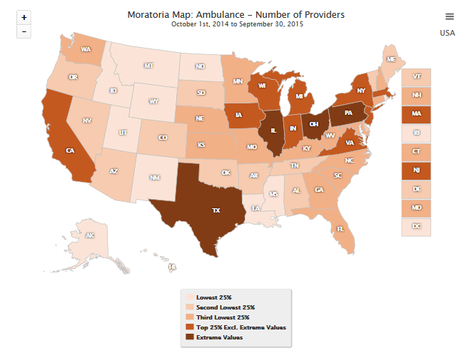
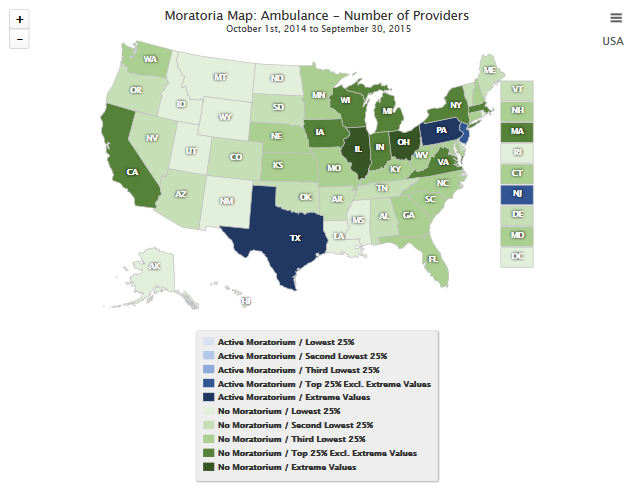
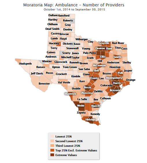
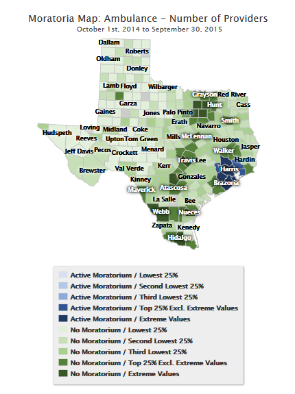
The interactive map is color-coded based on an analysis that separates the distribution into the following categories of states/counties for the selected metric: lowest 25 percent, second lowest 25 percent, third lowest 25 percent, top 25 percent excluding extreme values and extreme values. An extreme value is one that greatly differs from other values in its field (e.g., Number of Providers). Moratoria vs. non-moratoria states/counties are also identified based on color scheme. Counties that are excluded from the analysis are colored gray in the interactive map.
The examples below utilize the Ambulance Service Area data. Similar maps can be created through the Data Tool for all of the health service areas included in the second release and for the two twelve-month reference periods, 2014-10-01 to 2015-09-30 and 2015-01-01 to 2015-12-31.
Map 1 displays the distribution of providers by state for the Ambulance Service Area for the October 1, 2014 through September 30, 2015 reference period. This map utilizes a single color scale, which does not distinguish between moratoria and non-moratoria states.
Map 1. Ambulance: National Distribution of Number of Providers
October 1, 2014 â September 30, 2015
Single Color Scale
Â
Map 2 displays the distribution of providers by state for the October 1, 2014 through September 30, 2015 reference period. This map utilizes a dual color scale, which distinguishes between moratoria and non-moratoria states.
Map 2. Ambulance: National Distribution of Number of Providers
October 1, 2014 â September 30, 2015
Dual Color Scale
Using Texas as an example, Map 3 drills down to the county level and displays the distribution of providers by county within the State of Texas for the October 1, 2014 through September 30, 2015 reference period. This map utilizes a single color scale, which does not distinguish between moratoria and non-moratoria counties.
Map 3. Ambulance: County Distribution of Number of Providers
October 1, 2014 â September 30, 2015
Single Color Scale
Using Texas as an example, Map 4 drills down to the county level and displays the distribution of providers by county within the State of Texas for the October 1, 2014 through September 30, 2015 reference period. This map utilizes a dual color scale, which distinguishes between moratoria and non-moratoria counties.
Map 4. Ambulance: County Distribution of Number of Providers
October 1, 2014 â September 30, 2015
Dual Color Scale
Similar maps can be created at the national- and state-level for the following metrics: Number of FFS Beneficiaries, Average Number of Users per Provider, Percentage of Users out of FFS Beneficiaries, and Average Number of Providers per County.
###


